


 Proudly Canadian, est. 1999.


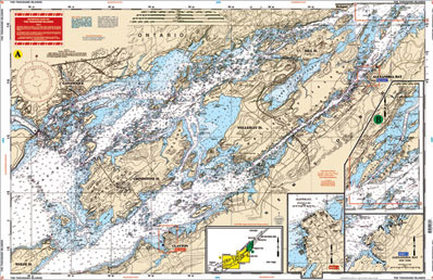
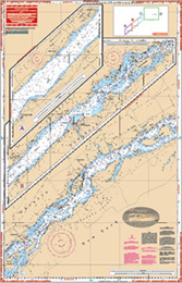
| The Thousand Islands SKU:78 Description: A great combination of several goverment charts. From Wolfe Island, this chart covers the Clayton and Gananoque area east to Wellesley Island, Hill Island, and Alexandria Bay. |
 |
 |
| Provides details of Clayton, Alexandria Bay. The reverse side covers the seaway from Dingman Point, northeast to Brockville and Morristown, New York. All you need for this popular summer area. Color key and large print place names make this chart exceptionally easy to use. Information from 4 NOAA Charts: 14767, 14766, 14765, and 14764. GPS Datum. Size: 25" x 38" | ||
|
|
||
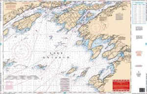
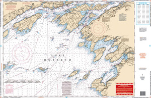
| Lake Ontario - N.E Lake Ontario SKU:76 Description: Entire lake coverage from Kingston to Hamilton on one side, with 35 GPS Waypoints indexed and indicated on the chart. |
 |
 |
|
Provides detailed coverage of the northeast section of the lake from Stony Point west to False Ducks Islands and north to Kingston and east to Clayton. Covers the Cape Vincent Area and the popular Sacketts Harbor and Henderson Harbor areas. A total of 16 GPS Waypoints are printed directly on the chart. Information from 2 NOAA Charts: 14802 and 14800. Size: 25" x 38" |
||
|
|
||
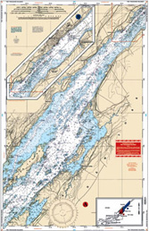
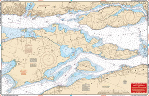
| N.E. Lake Ontario Kingston & Bateau Channel SKU:141 Description: Side one has detailed coverage of the islands and channels between Kingston, Ontario, and Cape Vincent, New York, east to the Wolfe Island Cut. |
 |
 |
|
Includes coverage of the Canadian Middle Channel and the Bateau Channel on the north side of Howe Isle. The reverse side covers Kingston and Clayton in a smaller scale, and provides a larger area, including all of Wolfe Island south to Stony Point and Henderson Harbor, and west to False Ducks Islands. Information from 3 NOAA charts: 14768, 14767, and 14802. GPS datum. Size: 25" x 38" |
||
|
|
||
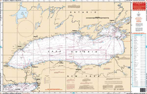
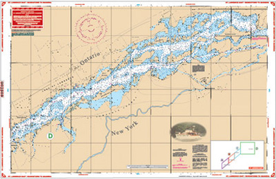
| St Lawrence East/Morristown to Massena SKU:78A Description: A combination of three Canadian Charts were used to create this chart # 1434, 1435, & 1433 and is the perfect chart if you are cruising the St Lawrence Seaway. |
 |
 |
|
Area includes Morristown on side "A" and continues east to Ogdenburg, Galop, Irooquois, and Ogden Islands. Side "B" starts at Morrisburg and continues east to Ault and Croil Islands, past Massena to Barnhart Island and the Moses-Saunders Power Dam. Many Anchorages and Marinas and speed zones are listed. See adjoining chart # 78 if you want full coverage from Wolfe Island to Morristown. Size: 25" x 38" |
||