


A common question we receive is: Do I need a chartplotter, or can I use my laptop as a chartplotter instead somehow? Does my old Garmin/Megallan handheld have any value?
There is no easy answer, but let's break electronic charting into 4 methods:
| 1 |
|
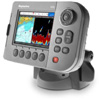
Stand-alone dedicated chartplotters or multi-functional displays (such as a Raymarine A, C or E series, Navman/Northstar, Standard Horizon, Garmin 420, etc) in conjunction with electronic charts (C-MAP, Navionics Gold, Garmin G2 Vision, etc) PROS: Dependable, easy to use, can be mounted in cockpit, great value. Displays huge amounts of data such as cross-track error and direct routing, and most can be set up to display fish-finding, depth, radar, tides, AIS info and much more. Good charting functionality though basic. CONS: Requires a specific format of chart - choose wisely. Difficult to find repairs/service on remote islands! |
|||||||
| 2 |
|
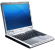
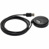
Ship's computer or laptop with GPS USB antenna (or perhaps your old handheld), navigation software and electronic charts. PROS: Huge choice of chart formats, including digitally-scanned images and GRiB files. Laptop can be used for various other tasks (movies, music, e-mail, weather info, office-work). Laptops can be serviced cheaply around the world. US charts (and other areas excluding Canada) can often be downloaded for free or shared. Usually very good charting functionality. Look for models with a "night view/dark screen" setting to save your eyes on the night watch. CONS: Laptops cannot be mounted outside (waterproof monitors and pointers are available but functionality is lackluster). Laptops crash, get viruses, fall, break and are vulnerable to lightning and surges. Better suited for computer-saavy boaters. Requires many components - can end up being the most expensive option depending on the software and charts purchased. Luckily, your old handheld GPS might be compatible to use as the antenna. |
|||||||
| 3 |
|
Handheld GPS with compatible charts. PROS: Simple, dependable, portable and easy. Waterproof. Inexpensive. Same GPS unit can be used for navigation on shore for other activities. Great as a back-up for emergencies. CONS: Small display so not recommended for serious or overnight navigation. Usually requires batteries. Requires charts of specific format. Charting functionality is severely limited. |
|||||||
| 4 |
|
Smartphone or iPhone with compatible charts PROS: Simple, easy to use, portable and can be incredibly cheap (US charts are free from NOAA. Canadian charts are not free!). Charting functionality is basic but decent. Can be used for multimedia and often weather info. CONS: Don't drop your phone overboard or get it wet! Small display - not recommended for serious navigation or overnight voyages. Does not display amount of info that chartplotters can give you, though other "apps" may exist. |
|||||||


Chartplotters (Option 1) are the best option, no doubt about it. It seems expensive but it really is an incredibly smart investment. You will never look back, especially if you are not particularily technologically saavy. If you are headed off-shore or navigating overnight, a chartplotter is a must-have. Sure, boaters have navigated around the world using paper charts for centuries.. but then again, mutinies weren't all that uncommon either.
Laptops and computers (Option 2) are becoming commonplace even on small boats and it is possible to turn them into powerful charting machines. It is especially useful for offshore long-distance sailing - using the laptop as a primary means of navigation with integrated e-mail, weather data. You can turn your laptop into a state-of-the-art communications/navigation/weather/multimedia machine! It's much cozy to plan voyages on a laptop in the cabin, rather than on the chartplotter in the cockpit. However, when navigating channels and harbours, this option is impractical unless you can bring the laptop outside.
Handheld GPS receivers (Option 3) are excellent... as a back-up! For dinghies and fishing boats, this type of system is often all you need. For bigger boats, handheld GPS receivers should be combined with paper charts and plotting tools at the nav station. Any overnight navigation is not recommended if this is your primary form of navigation unless you are confident with paper charts. All offshore sailors should carry at least 1 handheld GPS receiver in their ditch bag. Many sailors keep one in the stove during storms, just in case of lightning strikes (the stove might prevent the GPS from being damaged).
Smartphones or iPhones (Option 4) are exciting possibilities but should be treated just like Option 3 above.
The bottom line:
|
Some Recommended Products:
 |
GPS Chartplotter | See GPS Chartplotters page. |
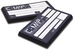 |
Electronic Charts: Card/Chip Format |
For more information, see products at top of this page! |
 |
Electronic Charts: CD-ROM Format |
For more information, see products at top of this page! |
| Charting Software |
For more information, see products at top of this page! |
|
 |
GPS-USB Antenna |
For more information, see products at top of this page! |
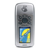 |
GPS Handhelds | See GPS Handheld page. |